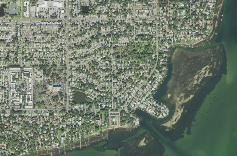
This guide concerns the named neighborhood in St. Petersburg. Association, historic-district, school and property boundaries can differ; use the responsible official source for an exact address.
Get to know Greater Pinellas Point
Greater Pinellas Point is a south St. Petersburg neighborhood identity with several different public destinations. A waterfront pause at Bay Vista Park, a recreation-center activity and a visit to Indian Mound Park each reveal something different about the area. Start with one, then decide whether to add another. The neighborhood’s broad coastal setting does not make every shoreline, dock or green space public, and a general map label does not establish access to the property nearest the water.
Use Bay Vista Park, listed at Fourth Street South and Pinellas Point Drive South, as a first waterfront orientation point. Choose a short park visit or a separately confirmed recreation activity. If local history is the priority, plan a distinct stop at Indian Mound Park at Mound Place South and Bethel Way South. Check the route between the two rather than assuming they share one park entrance.
Start with these local connections
- Give the two parks different roles
- Read the older landscape alongside the residential one
- Plan water access and recreation separately
- Check the address behind an everyday decision
Give the two parks different roles
Bay Vista Park’s city page lists a playground, boat ramps and the Bay Vista Recreation Center, with views toward the Sunshine Skyway Bridge. It provides a practical starting point for observing the waterfront without requiring a boat outing. Indian Mound Park serves a different purpose: the city identifies an Indigenous midden and on-site historical interpretation. Treat it as a cultural place to learn from, keeping to the current posted route and respecting the site. Neither destination should be used as a shortcut across adjoining homes, private docks or landscaped property.
Read the older landscape alongside the residential one
The preserved mound makes clear that the area’s history predates the modern residential streets. Use the city’s interpretation rather than assigning an age, ceremonial purpose or archaeological detail from an unsourced neighborhood description. The Greater Pinellas Point Civic Association provides a further community perspective through its facts, recreation and volunteer information. Those resources help introduce the broader area, but individual parks retain their own operators and rules. A neighborhood-wide amenity list does not mean that every named facility is next door or available under one booking.
Plan water access and recreation separately
A view across Tampa Bay is one experience; using a launch, joining a class or entering a pool is another. Open the particular city facility page and confirm the current access, parking and activity arrangements before bringing a trailer or recreation equipment. Do not read a boat-ramp listing as a promise of available trailer parking or suitable conditions for your vessel. For classes and youth activities, use St. Petersburg’s current registration catalog and verify the selected center. Public park access does not complete an activity registration, reserve a room or establish a team place.
Check the address behind an everyday decision
Test the journeys you would make from an actual home rather than from a broad Greater Pinellas Point map center. PSTA’s planner and current alerts help compare transit options in both directions. For schools, the district’s address lookup distinguishes the current 2026–27 result from published 2027–28 changes; nearby campuses are not automatic assignments. Ask St. Petersburg about city parks, streets and municipal services, and use official county contacts for county representation. For household-specific property, flood or evacuation questions, use the responsible official address tool instead of assuming that a waterfront neighborhood name gives the answer.
Neighborhood questions
Is Indian Mound Park the same place as Bay Vista Park?
No. They have separate city listings, locations and purposes. Plan a route between them if visiting both.
Does the neighborhood name establish public waterfront access?
No. Use the named public park or launch and its current instructions. Private shoreline and docks retain their own access arrangements.
Schools, civic contacts & everyday resources
Use your full street address for school and electoral questions. A city name, neighborhood label or nearby landmark does not establish the assignment for every home.
Official resource paths reviewed November 10, 2026. No household school or representative assignment is asserted here.
Find your bearings
Bay Vista Park is the orientation point on this map. The marker identifies one place; it does not draw the neighborhood, school zone or property boundary.
Public waterfront park. Boat launching, parking and recreation activities have their own current conditions and instructions.
Show the orientation map
Open a larger map ↗ · Official location source ↗ · Map data © OpenStreetMap contributors
Local information reviewed 2026-11-13. Photograph date and rights are recorded separately.
Useful reading
Choosing a Tampa Bay neighborhood: questions a listing cannot answer
Separate the place name from the address, then compare the everyday journeys and services that matter to you.
Getting around Tampa Bay: plan the actual journey
Match your destination to the right transport system and check both directions before committing to a day out.
Local sources & practical next steps
- Official city neighborhood-association source ↗
- Bay Vista Park — city facilities ↗
- Indian Mound Park — city historical site ↗
- Greater Pinellas Point Civic Association ↗
- Pinellas County Schools — current address lookup ↗
- PSTA — schedules, trip planner and service alerts ↗
- Pinellas County — Commission and civic contact routes ↗
Use current city, county and operator information for an exact address, opening hours, service access and event details.